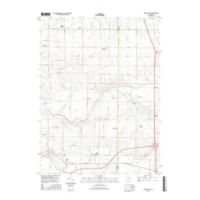
2016 Map of Twelve Mile
USGS Topo · Published 2016About this map
Twelve Mile serves as a primary hub in this northern Indiana landscape where the agricultural grid meets the winding courses of the Eel River and the Wabash River. The map documents a deeply established rural cemetery network, ranging from the historic Mount Carmel Cem to the modern Ever Rest Memorial Gardens near New Waverly. A complex drainage system of ditches and runs, such as Ulerich Ditch and Goose Run, illustrates the engineered nature of the local watershed, necessary for maintaining the productivity of the surrounding Cass and Miami County fields. Smaller settlements like Hoover and Mexico punctuate the intersections of county roads, while the presence of the Peru Municipal Airport and the heavy rail lines following the river valleys highlight the area's role as a regional transport corridor. For genealogists and local historians, the precise location of the Eel River Chapel Cem and Koontz Cem provides essential spatial context for families settled along the riverbanks.
Find a feature on this map
91 named features on this map. Tap any name to fly to it.
Don’t see what you’re looking for? This feature index may not catch every label — zoom into the map to look around manually.
Map Details
Editions of this 2016 Twelve Mile Map
This is the sole edition of this map. No revisions or reprints were ever made.
Other maps of this area

1951 · Peru
USGS Topo · 1:24,000

1951 · Onward
USGS Topo · 1:24,000

1951 · Twelve Mile
USGS Topo · 1:24,000

1951 · Bunker Hill
USGS Topo · 1:24,000

1953 · Danville
USGS Topo · 1:250,000

1955 · Danville
USGS Topo · 1:250,000

1955 · Logansport
USGS Topo · 1:24,000

1955 · Anoka
USGS Topo · 1:24,000

1956 · Danville
USGS Topo · 1:250,000
1960 · Peru
USGS Topo · 1:24,000