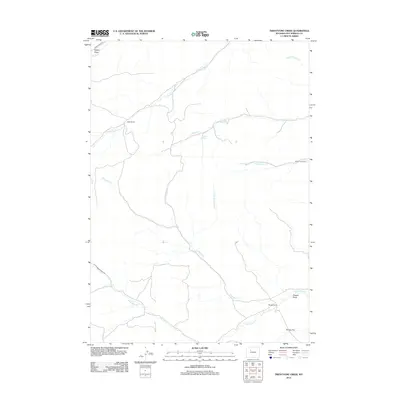
2012 Map of Twentyone Creek
USGS Topo · Published 2012About this map
Dickie Ranch and Rhodes Ranch anchor this landscape in Hot Springs County, where the high plains are defined by an intricate network of seasonal drainages and cattle camps. The geography here is dominated by the namesake Twentyone Cr, along with its east and west forks, which join as they flow toward the southeastern corner of the quadrangle. The map reveals the ranching infrastructure of the early 21st century, showing how modern corridors like Grass Creek Rd and Cottonwood Creek Rd follow the natural topography established by the many creek beds. Notable landmarks such as Putney Flat and the remote Rankin Cow Camp illustrate the sparse but deliberate human imprint on the land. Water sources like Pershal Spring remain vital in this arid environment, while dramatic terrain features like Egbert Draw and Dugout Draw carve through the basin.
Find a feature on this map
20 named features on this map. Tap any name to fly to it.
Don’t see what you’re looking for? This feature index may not catch every label — zoom into the map to look around manually.
Map Details
Editions of this 2012 Twentyone Creek Map
This is the sole edition of this map. No revisions or reprints were ever made.
Other maps of this area

1913 · Grass Creek Basin
USGS Topo · 1:62,500

1915 · Grass Creek Basin
USGS Topo · 1:62,500

1955 · Thermopolis
USGS Topo · 1:250,000

1956 · Milk Creek
USGS Topo · 1:24,000

1956 · Twentyone Creek
USGS Topo · 1:24,000

1956 · Soapy Dale Peak
USGS Topo · 1:24,000

1956 · Adam Weiss Peak
USGS Topo · 1:24,000

1958 · Thermopolis
USGS Topo · 1:250,000

1962 · Thermopolis
USGS Topo · 1:250,000
1965 · Embar
USGS Topo · 1:24,000