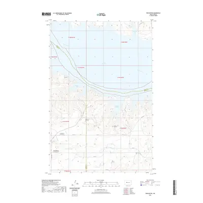
2020 Map of Twin Buttes
USGS Topo · Published 2020About this map
Lake Sakakawea dominates this high-plains landscape, where the waters of the Missouri River fill the broad coulees and bays of the Fort Berthold Indian Reservation. The settlement of Twin Buttes sits on the southern plateau, serving as a hub for a network of Bureau of Indian Affairs routes like BIA Rte 22 and BIA Rte 20. The distribution of local landmarks reflects a deeply rooted community history, marked by family and parish sites such as Saint Joseph's Catholic Church Cem and Crowsheart Cem. Further east, the rugged shoreline is punctuated by Medicine Stone Bay and Mandan Bay, with inland drainage provided by Malnourie Cr. The presence of the Fredericks Ranch Airport and various scattered cemeteries like Chase Cem and Holen Cem illustrate the modern agricultural and residential pattern of this Missouri River breaks country.
Find a feature on this map
32 named features on this map. Tap any name to fly to it.
Don’t see what you’re looking for? This feature index may not catch every label — zoom into the map to look around manually.
Map Details
Editions of this 2020 Twin Buttes Map
This is the sole edition of this map. No revisions or reprints were ever made.
Other maps of this area

1953 · Watford City
USGS Topo · 1:250,000

1957 · Watford City
USGS Topo · 1:250,000

1967 · Watford City
USGS Topo · 1:250,000

1967 · Raub SE
USGS Topo · 1:24,000

1967 · Raub NW
USGS Topo · 1:24,000

1967 · Raub
USGS Topo · 1:24,000

1967 · Twin Buttes
USGS Topo · 1:24,000

1970 · Halliday NE
USGS Topo · 1:24,000

1970 · Hay Flat
USGS Topo · 1:24,000
1970 · Golden Valley NE
USGS Topo · 1:24,000