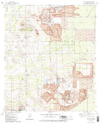
1981 Map of Twin Buttes
USGS Topo · Published 1981About this map
Large-scale industrial copper extraction defines the landscape south of Tucson, where the Mission Mine and Pima Mine dominate the northern terrain. This 1981 survey reveals an intricate network of Mine Dumps, Tailings Ponds, and a high-capacity Conveyor system supporting the local mining economy. The map preserves the locations of numerous smaller historical claims, including the Swastika Mine, Paymaster Mine, and Senator Morgan Mine, which are scattered among the foothills of Helmet Peak and Mineral Hill.
Find a feature on this map
39 named features on this map. Tap any name to fly to it.
Don’t see what you’re looking for? This feature index may not catch every label — zoom into the map to look around manually.
Map Details
Editions of this 1981 Twin Buttes Map
2 editions found
Other maps of this area

1904 · Patagonia
USGS Topo · 1:125,000

1904 · Tucson
USGS Topo · 1:125,000

1905 · Patagonia
USGS Topo · 1:125,000

1905 · Tucson
USGS Topo · 1:125,000

1920 · Arivaca
USGS Topo · 1:125,000

1925 · Samaniego Peak
USGS Topo · 1:62,500

1925 · San Xavier
USGS Topo · 1:62,500

1926 · Helvetia
USGS Topo · 1:62,500

1934 · Tucson Mountains
USGS Topo · 1:125,000

1939 · Twin Buttes
USGS Topo · 1:62,500