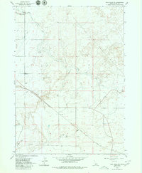
1979 Map of Twin Falls NE
USGS Topo · Published 1980About this map
The North Side Main Canal and its intricate network of distribution channels, such as the D 5 Ditch, define the agricultural landscape of Jerome Co. in this late 1970s survey. This map illustrates the vital infrastructure of Idaho's Magic Valley, where the Union Pacific railroad cuts a diagonal path through a grid of section lines and irrigation works. Industrial and community hubs are visible throughout the territory, including a local Grange Hall, a Substation, and the No 4 Pumping Station located near several Diversion Dams. Beyond the irrigated fields, the terrain is marked by extractive sites like Gravel Pits and a solitary Prospect, reflecting the local economy's reliance on both the soil and the underlying geology. The dense distribution of wells across the sheet further underscores the intensive water management required for the region's development.
Find a feature on this map
14 named features on this map. Tap any name to fly to it.
Don’t see what you’re looking for? This feature index may not catch every label — zoom into the map to look around manually.
Map Details
Editions of this 1979 Twin Falls NE Map
2 editions found
Other maps of this area

1955 · Twin Falls
USGS Topo · 1:250,000

1958 · Twin Falls
USGS Topo · 1:250,000

1964 · Kimberly
USGS Topo · 1:24,000

1964 · Falls City
USGS Topo · 1:24,000

1964 · Twin Falls
USGS Topo · 1:24,000

1964 · Eden
USGS Topo · 1:24,000

1964 · Perrine
USGS Topo · 1:24,000

1964 · Hunt
USGS Topo · 1:24,000

1971 · Shoshone SE
USGS Topo · 1:24,000

1971 · Star Lake
USGS Topo · 1:24,000