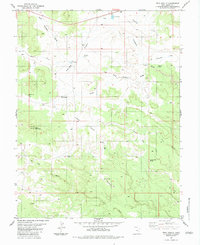
1983 Map of Twin Knolls
USGS Topo · Published 1983About this map
Twin Knolls and the surrounding high desert of Emery County appear here as they were documented in the mid-1970s and early 1980s. The landscape is defined by its water-carved topography, where drainage systems like Reid Neilson Draw and Crawford Draw cut across expansive plateaus like Indian Flat and Paige Flat. This map is particularly valuable for its recording of isolated water sources and livestock improvements in an arid environment, including The Big Pond, State Pond, and the curiously named Woodpile Pond. Evidence of land use and exploration is scattered throughout the terrain, from several Drill Holes and Prospects near Block Mountain to the network of unimproved routes like Earls Road. Named natural features such as Lone Man Butte and Ernie Canyon provide distinct landmarks for navigating the complex system of washes, notably the prominent Iron Wash that dominates the southern portion of the quadrangle.
Find a feature on this map
26 named features on this map. Tap any name to fly to it.
Don’t see what you’re looking for? This feature index may not catch every label — zoom into the map to look around manually.
Map Details
Editions of this 1983 Twin Knolls Map
2 editions found
Other maps of this area

1885 · San Rafael
USGS Topo · 1:250,000

1952 · Wild Horse
USGS Topo · 1:62,500

1952 · San Rafael Knob
USGS Topo · 1:62,500

1953 · Stinking Spring Creek 2 SE
USGS Topo · 1:24,000

1953 · Temple Mtn
USGS Topo · 1:62,500

1954 · Stinking Spring Creek 1 SE
USGS Topo · 1:24,000

1954 · Stinking Spring Creek 1 NW
USGS Topo · 1:24,000

1954 · Stinking Spring Creek 4 NE
USGS Topo · 1:24,000

1954 · Stinking Spring Creek 4 NW
USGS Topo · 1:24,000

1954 · Stinking Spring Creek 1 NE
USGS Topo · 1:24,000