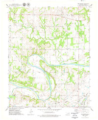
1975 Map of Twin Mounds
USGS Topo · Published 1979About this map
The Cimarron River carves a wide path through this Oklahoma landscape, defining the boundary between Pawnee County and Payne County. The terrain is marked by numerous Oil Wells and vast Oil Fields, illustrating the intense petroleum activity that shaped local development in the mid-1970s. Rural community life is anchored by gathering places such as the Council Valley Ch, Community Hall, and Hillside Sch, while the family history of the area is preserved in several burial grounds including Dunkin Cem and Bend Cem.
Find a feature on this map
44 named features on this map. Tap any name to fly to it.
Don’t see what you’re looking for? This feature index may not catch every label — zoom into the map to look around manually.
Map Details
Editions of this 1975 Twin Mounds Map
This is the sole edition of this map. No revisions or reprints were ever made.
Other maps of this area

1908 · Agra
USGS Topo · 1:62,500

1929 · Yale
USGS Topo · 1:62,500

1929 · Ripley
USGS Topo · 1:62,500

1931 · Drumright
USGS Topo · 1:62,500

1932 · Yale
USGS Topo · 1:62,500

1932 · Ripley
USGS Topo · 1:62,500

1954 · Oklahoma City
USGS Topo · 1:250,000

1955 · Enid
USGS Topo · 1:250,000

1957 · Oklahoma City
USGS Topo · 1:250,000

1958 · Enid
USGS Topo · 1:250,000