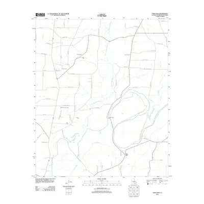
2012 Map of Twin Oaks
USGS Topo · Published 2012About this map
Bayou Bartholomew winds through this Morehouse Parish landscape, defining the local geography alongside tributaries like Chemin-A-Haut Bayou and Jelks Bayou. The terrain is characterized by its complex network of waterways and low-lying areas, including the swampy Pratt Brake. Small-scale infrastructure and rural settlements are scattered throughout, with the community of Twin Oaks and the Travis Airport serving as local landmarks. This survey provides significant detail for genealogical research, documenting several family and community burial grounds such as Causey Cem, Kelly Cem, and Neamon Cem. A intricate web of rural roads and trails, such as Beekman Tower Rd and Knox Ferry Rd, connects these sites to river crossings like Vester Bridge. The presence of the Beekman Lookout Tower underscores the area's history of forest management and fire observation.
Find a feature on this map
65 named features on this map. Tap any name to fly to it.
Don’t see what you’re looking for? This feature index may not catch every label — zoom into the map to look around manually.
Map Details
Editions of this 2012 Twin Oaks Map
This is the sole edition of this map. No revisions or reprints were ever made.
Other maps of this area

1935 · Wilmot
USGS Topo · 1:62,500

1935 · Naff
USGS Topo · 1:62,500

1935 · Bonita
USGS Topo · 1:62,500

1953 · Greenwood
USGS Topo · 1:250,000

1955 · Jackson
USGS Topo · 1:250,000

1956 · Greenwood
USGS Topo · 1:250,000

1956 · Bastrop
USGS Topo · 1:62,500

1958 · Bonita
USGS Topo · 1:62,500

1960 · Wilmot
USGS Topo · 1:62,500
1960 · Wilmot SW
USGS Topo · 1:24,000