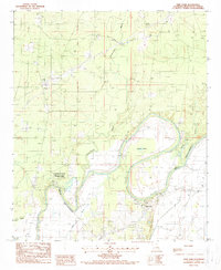
1988 Map of Twin Oaks
USGS Topo · Published 1988About this map
Chemin-A-Haut State Park anchors this Louisiana landscape, where the winding course of Bayou Bartholomew and Bayou Chemin-a-Haut define the local topography. In the late 1980s, the region shows a mix of recreational development and rural utility, with Campgrounds and a Boat Ramp supporting outdoor activity near the water. The settlement of Twin Oaks sits south of these bayou bends, while Beekman lies to the northwest, connected by a network of local roads and several Pipeline corridors.
Find a feature on this map
25 named features on this map. Tap any name to fly to it.
Don’t see what you’re looking for? This feature index may not catch every label — zoom into the map to look around manually.
Map Details
Editions of this 1988 Twin Oaks Map
This is the sole edition of this map. No revisions or reprints were ever made.
Other maps of this area

1935 · Wilmot
USGS Topo · 1:62,500

1935 · Naff
USGS Topo · 1:62,500

1935 · Bonita
USGS Topo · 1:62,500

1953 · Greenwood
USGS Topo · 1:250,000

1955 · Jackson
USGS Topo · 1:250,000

1956 · Greenwood
USGS Topo · 1:250,000

1956 · Bastrop
USGS Topo · 1:62,500

1958 · Bonita
USGS Topo · 1:62,500

1960 · Wilmot
USGS Topo · 1:62,500
1960 · Wilmot SW
USGS Topo · 1:24,000