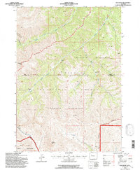
1991 Map of Twin Peaks
USGS Topo · Published 1997About this map
The Washakie Wilderness dominates this high-altitude landscape, where several major drainages carve through the central Absaroka Range. The map illustrates the convergence of several administrative and natural boundaries, including the Wind River Indian Reservation to the south and the Shoshone National Forest which encompasses much of the territory. The topography is defined by prominent summits such as Standard Peak, Dome Mountain, and the namesake Twin Peaks.
Find a feature on this map
22 named features on this map. Tap any name to fly to it.
Don’t see what you’re looking for? This feature index may not catch every label — zoom into the map to look around manually.
Map Details
Editions of this 1991 Twin Peaks Map
This is the sole edition of this map. No revisions or reprints were ever made.
Other maps of this area

1904 · Kirwin
USGS Topo · 1:125,000

1906 · Kirwin
USGS Topo · 1:125,000

1955 · Thermopolis
USGS Topo · 1:250,000

1958 · Thermopolis
USGS Topo · 1:250,000

1962 · Thermopolis
USGS Topo · 1:250,000

1967 · Willow Creek
USGS Topo · 1:24,000

1967 · Monument Peak
USGS Topo · 1:24,000
1967 · East Fork Basin
USGS Topo · 1:24,000
1969 · Cottonwood Peak
USGS Topo · 1:24,000
1969 · Twin Peaks
USGS Topo · 1:24,000