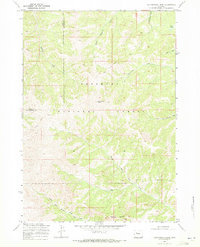
1969 Map of Cottonwood Peak
USGS Topo · Published 1971About this map
Shoshone National Forest defines the rugged topography of this 1969 field-checked survey, spanning the boundary between Park and Hot Springs counties. The area is characterized by high-elevation drainage systems, most notably where the North Fork Owl Creek and South Fork Owl Creek converge near the southern edge of the sheet. Rising prominently at the center is Cottonwood Peak, a landmark surrounded by an intricate network of seasonal waterways including Middle Gooseberry Creek and Chimney Creek. The sparse human footprint in this high-country landscape is represented by isolated outposts like Corral and Cow Camp, reflecting the seasonal grazing and forest management patterns of the mid-20th century. Researchers can trace the early trails and drainage divides that separated the Wind River basin from the Bighorn basin, anchored by geological formations like Castle Rocks.
Find a feature on this map
18 named features on this map. Tap any name to fly to it.
Don’t see what you’re looking for? This feature index may not catch every label — zoom into the map to look around manually.
Map Details
Editions of this 1969 Cottonwood Peak Map
2 editions found
Other maps of this area

1904 · Kirwin
USGS Topo · 1:125,000

1906 · Kirwin
USGS Topo · 1:125,000

1955 · Thermopolis
USGS Topo · 1:250,000

1956 · Milk Creek
USGS Topo · 1:24,000

1956 · Soapy Dale Peak
USGS Topo · 1:24,000

1958 · Thermopolis
USGS Topo · 1:250,000

1962 · Thermopolis
USGS Topo · 1:250,000
1965 · Eagle Nest Ranch
USGS Topo · 1:24,000

1967 · Willow Creek
USGS Topo · 1:24,000

1967 · Monument Peak
USGS Topo · 1:24,000