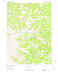
1969 Map of Cottonwood Peak
USGS Topo · Published 1972About this map
Shoshone National Forest dominates this high-altitude landscape along the border of Park and Hot Springs counties, centered on the prominent summit of Cottonwood Peak. The terrain is defined by a complex network of drainage systems, including Gooseberry Creek and the North Fork Owl Creek, which carve through the ridges. To the north, the waters of Middle Gooseberry Creek and Chimney Creek flow through narrow valleys, while the southeast is marked by the distinctive geological formations of Castle Rocks. Evidence of the region's ranching and wilderness utility is sparse but significant, with a Corral located near Cottonwood Creek and a Cow Camp situated along the lower reaches of the North Fork. These features, alongside high-mountain water bodies like Twin Lakes, illustrate a remote territory primarily used for seasonal grazing and resource management during the late 1960s.
Find a feature on this map
17 named features on this map. Tap any name to fly to it.
Don’t see what you’re looking for? This feature index may not catch every label — zoom into the map to look around manually.
Map Details
Editions of this 1969 Cottonwood Peak Map
2 editions found
Other maps of this area

1904 · Kirwin
USGS Topo · 1:125,000

1906 · Kirwin
USGS Topo · 1:125,000

1955 · Thermopolis
USGS Topo · 1:250,000

1956 · Milk Creek
USGS Topo · 1:24,000

1956 · Soapy Dale Peak
USGS Topo · 1:24,000

1958 · Thermopolis
USGS Topo · 1:250,000

1962 · Thermopolis
USGS Topo · 1:250,000
1965 · Eagle Nest Ranch
USGS Topo · 1:24,000

1967 · Willow Creek
USGS Topo · 1:24,000

1967 · Monument Peak
USGS Topo · 1:24,000