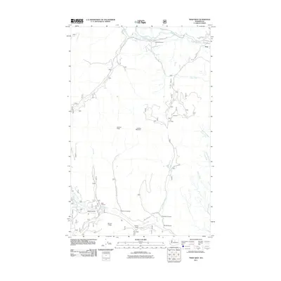
2011 Map of Twisp West
USGS Topo · Published 2011About this map
The town of Twisp sits at the confluence of the Twisp River and Alder Creek, serving as a gateway to the steep drainages of the eastern Cascades. This 2011 survey details a landscape defined by deep canyons and prominent ridgelines, including Lookout Ridge and Hornet Ridge. The presence of the Alder Mine on the slopes above the creek reflects the region's mining history, while the network of forest roads such as Poorman Creek Rd and Libby Creek Rd illustrates the modern infrastructure supporting timber and land management. The map tracks numerous seasonal and perennial watercourses, from Smith Canyon Creek to the various forks of Libby Creek, providing a clear record of the complex hydrology and terrain that shapes the Methow Valley area. Smaller features like Nickel Canyon and Ederberry Canyon underscore the intricate topographical detail captured in this digital-age topographic study.
Find a feature on this map
31 named features on this map. Tap any name to fly to it.
Don’t see what you’re looking for? This feature index may not catch every label — zoom into the map to look around manually.
Map Details
Editions of this 2011 Twisp West Map
This is the sole edition of this map. No revisions or reprints were ever made.
Other maps of this area

1899 · Methow
USGS Topo · 1:125,000

1901 · Methow
USGS Topo · 1:125,000

1955 · Concrete
USGS Topo · 1:250,000

1958 · Concrete
USGS Topo · 1:250,000

1962 · Concrete
USGS Topo · 1:250,000
1968 · Methow
USGS Topo · 1:24,000
1968 · Hungry Mtn
USGS Topo · 1:24,000
1969 · Martin Peak
USGS Topo · 1:24,000
1969 · Thompson Ridge
USGS Topo · 1:24,000
1969 · Buttermilk Butte
USGS Topo · 1:62,500