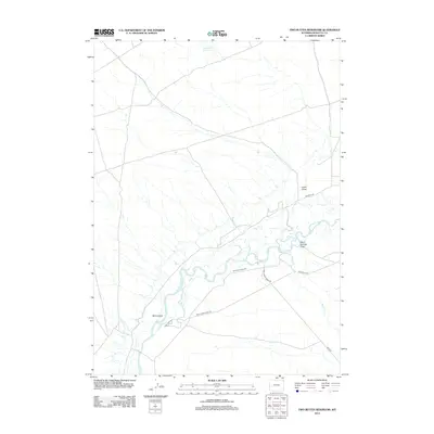
2012 Map of Two Buttes Reservoir
USGS Topo · Published 2012About this map
The New Fork River meanders across this Sublette County landscape, creating a complex network of braided channels and riparian features such as Mack Island. This 2012 survey by the U.S. Geological Survey documents a region defined by its water management and grazing infrastructure, anchored in the north by the Two Buttes Reservoir. The drainage patterns are clearly marked by named topographic features like Sand Springs Draw and Lovatt Draw, which feed into the main river system and Alkali Cr. A network of rural access routes, including Wild Horse Ranch Rd and Paradise Rd, provides the primary framework for movement through this high-desert terrain, reflecting the long-standing ranching and land-management practices of western Wyoming.
Find a feature on this map
12 named features on this map. Tap any name to fly to it.
Don’t see what you’re looking for? This feature index may not catch every label — zoom into the map to look around manually.
Map Details
Editions of this 2012 Two Buttes Reservoir Map
This is the sole edition of this map. No revisions or reprints were ever made.
Other maps of this area

1955 · Lander
USGS Topo · 1:250,000

1958 · Lander
USGS Topo · 1:250,000

1961 · Lander
USGS Topo · 1:250,000

1964 · Two Buttes Reservoir
USGS Topo · 1:24,000

1964 · Ross Butte
USGS Topo · 1:24,000

1964 · Boulder Lake
USGS Topo · 1:24,000
1964 · Olsen Ranch
USGS Topo · 1:24,000

1964 · Mount Airy
USGS Topo · 1:24,000

1964 · Mesa Spring
USGS Topo · 1:24,000

1964 · Boulder
USGS Topo · 1:24,000