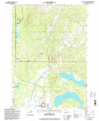
1996 Map of Two Ocean Lake
USGS Topo · Published 1998About this map
Jackson Lake Lodge serves as the primary human hub in a landscape dominated by complex waterways and high-altitude terrain at the northern edge of Grand Teton National Park. This mid-1990s record details the intersection of the Teton National Forest and the Teton Wilderness, where Pilgrim Creek and its tributaries like Middle Pilgrim Creek carve through the valley floor. The map highlights the significant glacial lakes, specifically Two Ocean Lake and Emma Matilda Lake, which are circumnavigated by the Two Ocean Lake Trail and Emma Matilda Lake Trail. South of Pilgrim Mountain, the landscape transitions into the marshy expanse of Willow Flats, dotted with landmarks such as Lunch Tree Hill and Christian Pond, illustrating the intricate drainage patterns that define this protected Wyoming ecosystem.
Find a feature on this map
30 named features on this map. Tap any name to fly to it.
Don’t see what you’re looking for? This feature index may not catch every label — zoom into the map to look around manually.
Map Details
Editions of this 1996 Two Ocean Lake Map
This is the sole edition of this map. No revisions or reprints were ever made.
Other maps of this area

1885 · Lake
USGS Topo · 1:125,000

1886 · Shoshone
USGS Topo · 1:125,000

1888 · Shoshone
USGS Topo · 1:125,000

1895 · Shoshone
USGS Topo · 1:125,000

1895 · Lake
USGS Topo · 1:125,000

1896 · Lake
USGS Topo · 1:125,000

1899 · Grand Teton
USGS Topo · 1:125,000

1901 · Shoshone
USGS Topo · 1:125,000

1901 · Lake
USGS Topo · 1:125,000

1901 · Grand Teton
USGS Topo · 1:125,000