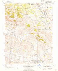
1954 Map of Two Rock
USGS Topo · Published 1955About this map
The Two Rock Ranch Station Military Reservation anchors the southern landscape of this Sonoma County map, situated just north of the Sonoma Co and Marin Co line. In the mid-1950s, this area reflects a rural economy shaped by ranching and small farming communities such as Bloomfield, Hessel, and Cunningham. The terrain is defined by the winding course of Americano Creek and the low elevations of English Hill, while the northeastern corner transitions toward the Laguna de Santa Rosa wetlands. Local education history is remarkably preserved through a high density of rural schoolhouses, from the Eucalyptus School to the Two Rock Sch (Aban'd). The map also captures the path of the Petaluma and Santa Rosa rail line as it moves through small stops like Cadwell and Turner, illustrating the transit-connected agricultural life of the North Bay before modern highway expansion.
Find a feature on this map
47 named features on this map. Tap any name to fly to it.
Don’t see what you’re looking for? This feature index may not catch every label — zoom into the map to look around manually.
Map Details
Editions of this 1954 Two Rock Map
3 editions found
Other maps of this area

1914 · Petaluma
USGS Topo · 1:62,500

1916 · Santa Rosa
USGS Topo · 1:62,500

1916 · Point Reyes
USGS Topo · 1:48,000

1918 · Point Reyes
USGS Topo · 1:62,500

1935 · Sebastopol
USGS Topo · 1:48,000

1942 · Sebastopol
USGS Topo · 1:62,500

1942 · Petaluma
USGS Topo · 1:62,500

1944 · Santa Rosa
USGS Topo · 1:62,500

1947 · Santa Rosa
USGS Topo · 1:250,000

1949 · Santa Rosa
USGS Topo · 1:250,000