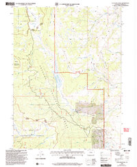
2000 Map of Tyler Mountain
USGS Topo · Published 2004About this map
Tyler Mountain rises as the central landmark in this high-country landscape at the beginning of the twenty-first century, marking the boundary where Routt National Forest meets Arapaho National Forest. The map documents a rugged drainage network defined by the Sarvis Creek Wilderness to the west and the intricate forks of Red Dirt Creek and North Fork Deer Creek. Water management and natural flow dominate the terrain, from the Red Dirt Reservoir, also identified as Mc Mahon Res No 2, to the artificial channel of the Smith Ditch. This era of the landscape is characterized by its recreational and conservation designations, including the Silver Creek Trail and various unpaved 4WD routes that penetrate the forest. Localized human activity is visible at Kasdorf and several Gravel Pits, illustrating the modest infrastructure supporting this mountain region.
Find a feature on this map
26 named features on this map. Tap any name to fly to it.
Don’t see what you’re looking for? This feature index may not catch every label — zoom into the map to look around manually.
Map Details
Editions of this 2000 Tyler Mountain Map
This is the sole edition of this map. No revisions or reprints were ever made.
Other maps of this area

1954 · Craig
USGS Topo · 1:250,000

1956 · Lake Agnes
USGS Topo · 1:24,000

1956 · Kremmling
USGS Topo · 1:62,500

1956 · Whiteley Peak
USGS Topo · 1:24,000

1956 · Walton Peak
USGS Topo · 1:24,000

1956 · Gore Pass
USGS Topo · 1:62,500

1956 · Hyannis Peak
USGS Topo · 1:62,500

1956 · Rabbit Ears Peak
USGS Topo · 1:62,500

1957 · Craig
USGS Topo · 1:250,000

1958 · Craig
USGS Topo · 1:250,000