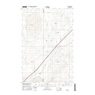
2017 Map of Tyler
USGS Topo · Published 2017About this map
The settlement of Tyler occupies a central position in this corner of Spokane County, situated along the diagonal corridor of the S Columbia Basin Hwy. The landscape transitions from the agricultural plateaus of the north to the distinctive coulees and lake basins of the Channeled Scablands in the south. The small community of Fishtrap lies near the southwestern edge of the map, adjacent to the sprawling waters of Hog Lake. The topography is defined by seasonal water systems and depressions, such as Hog Canyon and Turtle Hole, reflecting the area's unique geological heritage. Transportation is a primary theme, with a dense network of rural routes like S Malloy Prairie Rd and Tyler Rd connecting the scattered meadows of Moreland Meadow and Bennett Meadow. These roads trace the property lines of the Public Land Survey System, which divides the region into Township 22 and 23 North.
Find a feature on this map
42 named features on this map. Tap any name to fly to it.
Don’t see what you’re looking for? This feature index may not catch every label — zoom into the map to look around manually.
Map Details
Editions of this 2017 Tyler Map
This is the sole edition of this map. No revisions or reprints were ever made.
Other maps of this area

1943 · Medical Lake
USGS Topo · 1:62,500

1945 · Reardan
USGS Topo · 1:62,500

1953 · Reardan
USGS Topo · 1:62,500

1954 · Medical Lake
USGS Topo · 1:24,000

1954 · Medical Lake
USGS Topo · 1:62,500

1954 · Cheney
USGS Topo · 1:62,500

1954 · Sprague
USGS Topo · 1:62,500

1955 · Spokane
USGS Topo · 1:250,000

1958 · Spokane
USGS Topo · 1:250,000
1963 · Medical Lake
USGS Topo · 1:24,000