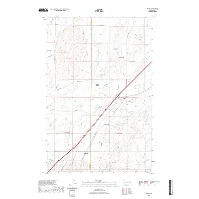
2020 Map of Tyler
USGS Topo · Published 2020About this map
Tyler and Fishtrap anchor this 2020 landscape along the border of Lincoln and Spokane counties. The terrain is defined by a series of distinct basalt coulees and scablands, typical of this region's geology, featuring prominent landmarks like Hog Canyon and the surrounding Hog Lake. Local history and genealogy interests are centered at the Rockdale Cem in the northwest, while the agricultural and ranching legacy of the area is evident in named open spaces such as Bennett Meadow and Moreland Meadow. The transportation network relies heavily on the S Columbia Basin Hwy, which cuts diagonally across the quadrangle, passing near unique hydrological features like the Turtle Hole and tracing the path of Rock Cr. This modern survey provides a detailed look at the rural property divisions and named roads that have shaped the community over decades.
Find a feature on this map
43 named features on this map. Tap any name to fly to it.
Don’t see what you’re looking for? This feature index may not catch every label — zoom into the map to look around manually.
Map Details
Editions of this 2020 Tyler Map
This is the sole edition of this map. No revisions or reprints were ever made.
Other maps of this area

1943 · Medical Lake
USGS Topo · 1:62,500

1945 · Reardan
USGS Topo · 1:62,500

1953 · Reardan
USGS Topo · 1:62,500

1954 · Medical Lake
USGS Topo · 1:24,000

1954 · Medical Lake
USGS Topo · 1:62,500

1954 · Cheney
USGS Topo · 1:62,500

1954 · Sprague
USGS Topo · 1:62,500

1955 · Spokane
USGS Topo · 1:250,000

1958 · Spokane
USGS Topo · 1:250,000
1963 · Medical Lake
USGS Topo · 1:24,000