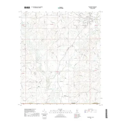
2018 Map of Tylertown
USGS Topo · Published 2018About this map
Tylertown serves as the focal point of this Mississippi landscape, situated just north of the border between Walthall Co and Washington Parish, Louisiana. The town's grid is defined by historic thoroughfares like Beulah Ave and Magnolia Ave, while the surrounding rural landscape is divided by the meandering courses of the Bogue Chitto and Magee Creek. Smaller settlements such as Lexie, Dillon, and Lehr are scattered across the terrain, reflecting a long-standing pattern of southern agricultural life.
Find a feature on this map
105 named features on this map. Tap any name to fly to it.
Don’t see what you’re looking for? This feature index may not catch every label — zoom into the map to look around manually.
Map Details
Editions of this 2018 Tylertown Map
This is the sole edition of this map. No revisions or reprints were ever made.
Other maps of this area

1939 · Sunny Hill
USGS Topo · 1:31,680

1939 · Clifton
USGS Topo · 1:31,680

1942 · Thomas
USGS Topo · 1:31,680

1953 · Natchez
USGS Topo · 1:250,000

1954 · Baton Rouge
USGS Topo · 1:250,000

1956 · Natchez
USGS Topo · 1:250,000

1956 · Baton Rouge
USGS Topo · 1:250,000
1958 · Mount Hermon
USGS Topo · 1:62,500
1958 · Franklinton
USGS Topo · 1:62,500

1959 · Natchez
USGS Topo · 1:250,000