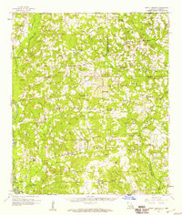
1958 Map of Mount Hermon
USGS Topo · Published 1959About this map
The Tangipahoa River and Illinois Central railroad corridor define the western edge of this 1950s landscape, anchored by the rail town of Kentwood. This era of the Florida Parishes shows a dense network of family-named cemeteries and rural congregations, reflecting the deep-rooted settlement patterns of Tangipahoa Parish and Washington Parish. High points like the Sunny Hill Lookout Tower overlook a terrain carved by the Chefuncte River and Big Creek.
Find a feature on this map
86 named features on this map. Tap any name to fly to it.
Don’t see what you’re looking for? This feature index may not catch every label — zoom into the map to look around manually.
Map Details
Editions of this 1958 Mount Hermon Map
3 editions found
Other maps of this area

1939 · Sunny Hill
USGS Topo · 1:31,680

1939 · Clifton
USGS Topo · 1:31,680

1940 · Spring Creek
USGS Topo · 1:31,680

1940 · Roseland
USGS Topo · 1:31,680

1942 · Roseland
USGS Topo · 1:31,680

1942 · Husser
USGS Topo · 1:31,680

1942 · Wilmer
USGS Topo · 1:31,680

1942 · Loranger
USGS Topo · 1:31,680

1949 · Bolivar
USGS Topo · 1:31,680

1949 · Amite
USGS Topo · 1:31,680