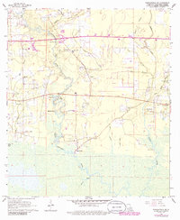
1968 Map of Ponchatoula NE
USGS Topo · Published 1986About this map
The Tangipahoa River carves a winding path through the heart of this Louisiana landscape, defining the character of the riverine lowlands between Ponchatoula and the wetlands to the south. During the late 1960s and into the 1970s, this area maintained a balance of rural settlement and natural marshland. Waterway access was central to local life, anchored by points like Lees Landing and Traino Landing on the southern reaches of the river and Bedico Creek. Numerous family cemeteries, such as Robertson Cem and Edwards Cem, alongside landmarks like Champ Cooper Sch and Wesley Chapel, reveal a deeply rooted community infrastructure. Toward the bottom of the map, the terrain gives way to the expansive marshes of Black Bayou and Rice Bayou, where a network of lakes including Mitchells Lake and Dead Lake dots the cypress-studded basin.
Find a feature on this map
38 named features on this map. Tap any name to fly to it.
Don’t see what you’re looking for? This feature index may not catch every label — zoom into the map to look around manually.
Map Details
Editions of this 1968 Ponchatoula NE Map
4 editions found
Other maps of this area

1935 · Covington
USGS Topo · 1:62,500

1935 · Ponchatoula
USGS Topo · 1:62,500

1939 · Ponchatoula
USGS Topo · 1:62,500

1939 · Covington
USGS Topo · 1:62,500

1940 · Tickfaw
USGS Topo · 1:31,680

1942 · Onville
USGS Topo · 1:31,680

1942 · Robert
USGS Topo · 1:31,680

1950 · Covington
USGS Topo · 1:62,500

1951 · Ponchatoula
USGS Topo · 1:62,500

1954 · Folsom
USGS Topo · 1:62,500