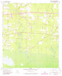
1968 Map of Ponchatoula NE
USGS Topo · Published 1980About this map
Lees Landing sits near the confluence of the Tangipahoa River and Rice Bayou, serving as a focal point for this wetland-heavy landscape in Tangipahoa Parish. The 1968 topography reveals a social fabric built around small country churches and family burial grounds, including Wesley Chapel, Good Hope Ch, and Sand Hill Cem. To the east, the Bedico Creek and East Bedico Creek systems define the drainage patterns, while the Champ Cooper Sch provides a glimpse into the local educational infrastructure of the mid-20th century. The intricate network of small waterways like P-Kaw Shun Creek and Mile Branch shows how the terrain dictated rural settlement, with small family holdings and cemeteries like Collins Cem and Edwards Cem positioned on the higher ground between bayous and sloughs.
Find a feature on this map
40 named features on this map. Tap any name to fly to it.
Don’t see what you’re looking for? This feature index may not catch every label — zoom into the map to look around manually.
Map Details
Editions of this 1968 Ponchatoula NE Map
4 editions found
Other maps of this area

1935 · Covington
USGS Topo · 1:62,500

1935 · Ponchatoula
USGS Topo · 1:62,500

1939 · Ponchatoula
USGS Topo · 1:62,500

1939 · Covington
USGS Topo · 1:62,500

1940 · Tickfaw
USGS Topo · 1:31,680

1942 · Onville
USGS Topo · 1:31,680

1942 · Robert
USGS Topo · 1:31,680

1950 · Covington
USGS Topo · 1:62,500

1951 · Ponchatoula
USGS Topo · 1:62,500

1954 · Folsom
USGS Topo · 1:62,500