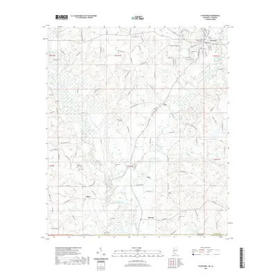
2020 Map of Tylertown
USGS Topo · Published 2020About this map
Tylertown serves as the focal point of this modern survey of south-central Mississippi, where the Walthall County Courthouse stands near the intersection of several regional routes. The settlement pattern is defined by a series of smaller communities including Lexie, Lehr, and Simonds, connected by a network of local roads that follow the winding paths of Bogue Chitto and Magees Creek. For genealogists, the landscape is densely populated with family-named burial grounds, such as the Needham Alford Cem, Holmes Cem, and Duncan Cem. The southern edge of the map tracks the Mississippi-Louisiana state line, illustrating the transition from Walthall County into Louisiana’s Washington Parish. Significant water features like Harveys Pond and Popes Cr punctuate the wooded and agricultural terrain surrounding the Tylertown Cemetery.
Find a feature on this map
61 named features on this map. Tap any name to fly to it.
Don’t see what you’re looking for? This feature index may not catch every label — zoom into the map to look around manually.
Map Details
Editions of this 2020 Tylertown Map
This is the sole edition of this map. No revisions or reprints were ever made.
Other maps of this area

1939 · Sunny Hill
USGS Topo · 1:31,680

1939 · Clifton
USGS Topo · 1:31,680

1942 · Thomas
USGS Topo · 1:31,680

1953 · Natchez
USGS Topo · 1:250,000

1954 · Baton Rouge
USGS Topo · 1:250,000

1956 · Natchez
USGS Topo · 1:250,000

1956 · Baton Rouge
USGS Topo · 1:250,000
1958 · Mount Hermon
USGS Topo · 1:62,500
1958 · Franklinton
USGS Topo · 1:62,500

1959 · Natchez
USGS Topo · 1:250,000