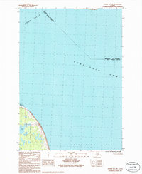
1986 Map of Tyonek A-1 SW
USGS Topo · Published 1986About this map
Point Possession marks the northern tip of the peninsula where the waters of Cook Inlet meet the Turnagain Arm. This mid-1980s provisional study details a significant transition zone where the Municipality of Anchorage meets the Kenai Peninsula Borough boundary across the marine channels. The landscape is dominated by the protected coastal reaches of the Kenai National Wildlife Refuge and the Kenai Wilderness, showing a terrain largely defined by its natural state. Small inland water bodies like Diamond Lake and Cook Lake sit just behind the shoreline, while the expansive mudflats of Chickaloon Bay and the distant profile of Fire Island illustrate the dynamic tidal environment of this Alaskan maritime region.
Find a feature on this map
10 named features on this map. Tap any name to fly to it.
Don’t see what you’re looking for? This feature index may not catch every label — zoom into the map to look around manually.
Map Details
Editions of this 1986 Tyonek A-1 SW Map
This is the sole edition of this map. No revisions or reprints were ever made.
Other maps of this area

1944 · Kenai
USGS Topo · 1:250,000

1949 · Tyonek
USGS Topo · 1:250,000

1950 · Kenai
USGS Topo · 1:250,000

1951 · Tyonek
USGS Topo · 1:250,000

1951 · Kenai D-1
USGS Topo · 1:63,360

1951 · Kenai D-2
USGS Topo · 1:63,360

1951 · Tyonek A-2
USGS Topo · 1:63,360

1951 · Tyonek A-1
USGS Topo · 1:63,360

1952 · Kenai D-2
USGS Topo · 1:63,360

1952 · Tyonek A-2
USGS Topo · 1:63,360