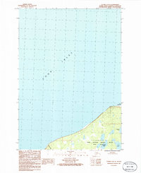
1986 Map of Tyonek A-2 SE
USGS Topo · Published 1986About this map
Point Possession marks a prominent geographic bend on the northern edge of the Kenai Peninsula, overlooking the expansive waters of Cook Inlet. This mid-1980s provisional survey illustrates a landscape primarily defined by protected conservation areas, with much of the interior territory falling within the Kenai National Wildlife Refuge and the strictly managed Kenai Wilderness.
Find a feature on this map
9 named features on this map. Tap any name to fly to it.
Don’t see what you’re looking for? This feature index may not catch every label — zoom into the map to look around manually.
Map Details
Editions of this 1986 Tyonek A-2 SE Map
This is the sole edition of this map. No revisions or reprints were ever made.
Other maps of this area

1944 · Kenai
USGS Topo · 1:250,000

1949 · Tyonek
USGS Topo · 1:250,000

1950 · Kenai
USGS Topo · 1:250,000

1951 · Tyonek
USGS Topo · 1:250,000

1951 · Kenai D-1
USGS Topo · 1:63,360

1951 · Kenai D-2
USGS Topo · 1:63,360

1951 · Tyonek A-2
USGS Topo · 1:63,360

1951 · Tyonek A-1
USGS Topo · 1:63,360

1952 · Kenai D-2
USGS Topo · 1:63,360

1952 · Tyonek A-2
USGS Topo · 1:63,360