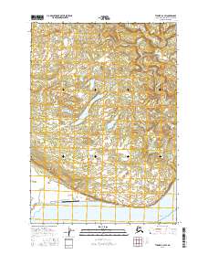
2016 Map of Tyonek A-4 SW
USGS Topo · Published 2016About this map
Trading Bay and the northern reaches of the Pacific Ocean define the coastal character of this West Cook Inlet landscape. The terrain is marked by a complex network of wetlands and small water bodies, including Congahbuna Lake and several meandering drainage systems such as Old Tyonek Cr and Nikolai Creek. Inland, the geography is largely undeveloped, though human presence is anchored by the Nikolai Creek Airport near the coast and the distinct topographical marker of Granite Point overlooking the bay. The map illustrates a remote Alaskan wilderness where freshwater systems like the Chuitna River and Tyonek Cr converge toward the salt water. The absence of a major road network highlights the isolation of this region in the early 21st century, relying instead on coastal landmarks and small airfields for access.
Find a feature on this map
14 named features on this map. Tap any name to fly to it.
Don’t see what you’re looking for? This feature index may not catch every label — zoom into the map to look around manually.
Map Details
Editions of this 2016 Tyonek A-4 SW Map
This is the sole edition of this map. No revisions or reprints were ever made.
Other maps of this area

1944 · Kenai
USGS Topo · 1:250,000

1949 · Tyonek
USGS Topo · 1:250,000

1950 · Kenai
USGS Topo · 1:250,000

1950 · Kenai D-4
USGS Topo · 1:63,360

1951 · Tyonek
USGS Topo · 1:250,000

1952 · Kenai D-4
USGS Topo · 1:63,360

1958 · Tyonek A-5
USGS Topo · 1:63,360

1958 · Tyonek A-4
USGS Topo · 1:63,360

1958 · Kenai D-5
USGS Topo · 1:63,360

1958 · Tyonek
USGS Topo · 1:250,000