
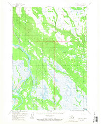
1958 Map of Tyonek A-5
USGS Topo · Published 1961About this map
The braided river systems of the Kenai Peninsula dominate this late-1950s survey, illustrating a landscape defined by shifting watercourses and vast tidal flats. The Chakachatna River and Mc Arthur River carve wide, sediment-rich paths toward the coast, joined by smaller tributaries like Chuitkilnachna Creek and Nikolai Creek. Near the southern edge of the map, the Noaukta Slough and Middle River create a complex network of wetlands that transition into the Trading Bay tidal flats.
Find a feature on this map
13 named features on this map. Tap any name to fly to it.
Don’t see what you’re looking for? This feature index may not catch every label — zoom into the map to look around manually.
Map Details
Editions of this 1958 Tyonek A-5 Map
2 editions found
Other maps of this area

1944 · Kenai
USGS Topo · 1:250,000

1949 · Tyonek
USGS Topo · 1:250,000

1950 · Kenai
USGS Topo · 1:250,000

1950 · Kenai D-4
USGS Topo · 1:63,360

1951 · Tyonek
USGS Topo · 1:250,000

1952 · Kenai D-4
USGS Topo · 1:63,360

1954 · Tyonek B-4
USGS Topo · 1:63,360

1958 · Tyonek A-6
USGS Topo · 1:63,360

1958 · Tyonek A-4
USGS Topo · 1:63,360

1958 · Tyonek B-5
USGS Topo · 1:63,360