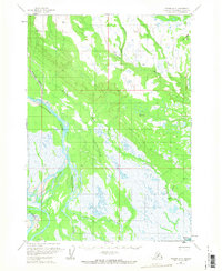
1958 Map of Tyonek A-5
USGS Topo · Published 1968About this map
Trading Bay and the low-lying coastal marshes of the western Cook Inlet define this 1950s landscape, where complex glacial drainage systems meet the tide. This survey, compiled from early-1950s aerial photography, documents a wilderness of saturated wetlands and shifting river braids before significant modern development. The Chakachatna River and Mc Arthur River dominate the hydrology of the area, feeding into the bay alongside the Middle River. These waterways are flanked by the Noaukta Slough and numerous unnamed ponds, illustrating the intricate seasonal flooding patterns of the region.
Find a feature on this map
19 named features on this map. Tap any name to fly to it.
Don’t see what you’re looking for? This feature index may not catch every label — zoom into the map to look around manually.
Map Details
Editions of this 1958 Tyonek A-5 Map
2 editions found
Other maps of this area

1944 · Kenai
USGS Topo · 1:250,000

1949 · Tyonek
USGS Topo · 1:250,000

1950 · Kenai
USGS Topo · 1:250,000

1950 · Kenai D-4
USGS Topo · 1:63,360

1951 · Tyonek
USGS Topo · 1:250,000

1952 · Kenai D-4
USGS Topo · 1:63,360

1954 · Tyonek B-4
USGS Topo · 1:63,360

1958 · Tyonek A-6
USGS Topo · 1:63,360

1958 · Tyonek A-5
USGS Topo · 1:63,360

1958 · Tyonek A-4
USGS Topo · 1:63,360