
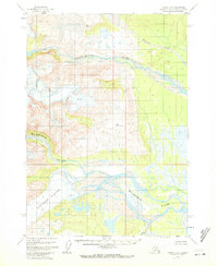
1958 Map of Tyonek A-6
USGS Topo · Published 1961About this map
Blockade Glacier dominates the western portion of this 1950s Alaskan wilderness, where the ice meets a landscape defined by braided river systems and volcanic activity. The Mc Arthur River and Chakachatna River carve through the terrain, depositing silt and creating wide, marshy deltas. High-altitude survey markers like VABM 3213 Chaka and VABM 2351 McArthur help define the dramatic elevation changes from the valley floors to the glaciated peaks. A layer of Volcanic Ash is noted in the northwest, serving as a physical marker of the region's active geology. The map illustrates a transitional environment where heavy glaciation, indicated by dangerous Crevasses, transitions into the lower Straight Creek basin. This survey provides a baseline of the glacial extent and drainage patterns before modern environmental shifts altered the reach of these ice fields.
Find a feature on this map
10 named features on this map. Tap any name to fly to it.
Don’t see what you’re looking for? This feature index may not catch every label — zoom into the map to look around manually.
Map Details
Editions of this 1958 Tyonek A-6 Map
2 editions found
Other maps of this area

1944 · Kenai
USGS Topo · 1:250,000

1949 · Tyonek
USGS Topo · 1:250,000

1950 · Kenai
USGS Topo · 1:250,000

1951 · Tyonek
USGS Topo · 1:250,000

1958 · Tyonek A-5
USGS Topo · 1:63,360

1958 · Tyonek B-5
USGS Topo · 1:63,360

1958 · Tyonek B-6
USGS Topo · 1:63,360

1958 · Kenai D-5
USGS Topo · 1:63,360

1958 · Kenai D-6
USGS Topo · 1:63,360

1958 · Kenai D-7
USGS Topo · 1:63,360