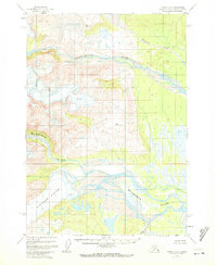
1958 Map of Tyonek A-6
USGS Topo · Published 1972About this map
The Blockade Glacier dominates the western half of this Kenai Peninsula landscape, showing the complex ice and water systems of mid-century Alaska. The drainage pattern is defined by the powerful Chakachatna River to the north and the McArthur River to the south, both of which feed into a network of braided streams and marshy lowlands. High-altitude triangulation stations like VABM Chaka 3213 and VABM 2351 McArthur mark the peaks between these massive glacial flows.
Find a feature on this map
10 named features on this map. Tap any name to fly to it.
Don’t see what you’re looking for? This feature index may not catch every label — zoom into the map to look around manually.
Map Details
Editions of this 1958 Tyonek A-6 Map
2 editions found
Other maps of this area

1944 · Kenai
USGS Topo · 1:250,000

1949 · Tyonek
USGS Topo · 1:250,000

1950 · Kenai
USGS Topo · 1:250,000

1951 · Tyonek
USGS Topo · 1:250,000

1958 · Tyonek A-6
USGS Topo · 1:63,360

1958 · Tyonek A-5
USGS Topo · 1:63,360

1958 · Tyonek B-5
USGS Topo · 1:63,360

1958 · Tyonek B-6
USGS Topo · 1:63,360

1958 · Kenai D-5
USGS Topo · 1:63,360

1958 · Kenai D-6
USGS Topo · 1:63,360