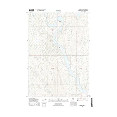
2016 Map of Tyonek C-2 NW
USGS Topo · Published 2016About this map
The Yentna River winds through this section of the Matanuska-Susitna Borough, defining a landscape of braided channels and riparian complexity. This 2016 survey illustrates the vital role of aviation in accessing this roadless region, highlighting isolated landing sites like Yentna Bend Strip Airport and Jewell Airport. These small strips are often the primary link for residents and seasonal visitors in the Alaskan interior. To the north, the river passes by Sdak'dal'iy, while Alexander Creek contributes to the intricate drainage network of the valley. The map provides a detailed view of the terrain within several townships, including t19n r8w and t18n r7w, showing the subtle elevation changes and wetland patterns that characterize this riverine environment.
Find a feature on this map
9 named features on this map. Tap any name to fly to it.
Don’t see what you’re looking for? This feature index may not catch every label — zoom into the map to look around manually.
Map Details
Editions of this 2016 Tyonek C-2 NW Map
This is the sole edition of this map. No revisions or reprints were ever made.
Other maps of this area

1949 · Tyonek
USGS Topo · 1:250,000

1951 · Tyonek
USGS Topo · 1:250,000

1954 · Tyonek D-2
USGS Topo · 1:63,360

1954 · Tyonek D-3
USGS Topo · 1:63,360

1954 · Tyonek C-3
USGS Topo · 1:63,360

1958 · Tyonek C-2
USGS Topo · 1:63,360

1958 · Tyonek
USGS Topo · 1:250,000

1965 · Tyonek
USGS Topo · 1:250,000
1993 · Tyonek D-3
USGS Topo · 1:63,360
1993 · Tyonek D-2
USGS Topo · 1:63,360