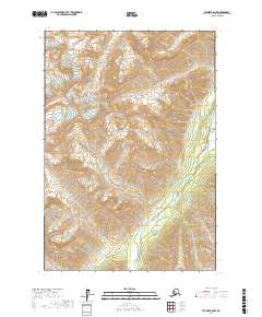
2017 Map of Tyonek C-8 NW
USGS Topo · Published 2017About this map
The Alaska Range dominates this landscape in the Matanuska-Susitna Borough, where steep topographic contours reveal the high elevations and drainage patterns of the northern wilderness. The broad valley of the Skwentna River cuts through the southeastern corner of the quadrangle, serving as a primary hydrological artery for the surrounding peaks. This 2017 survey details a remote area defined by glacial and snowmelt-fed tributaries, including the sharp descent of Crystal Cr and Emerald Cr. The land is divided into large sections of the Public Land Survey System, specifically Townships 18 and 19 North, covering Ranges 20 and 21 West. The absence of roads or permanent settlements on this sheet highlights the isolation of this portion of the range, preserved here in high-resolution detail for land management and geological study.
Find a feature on this map
8 named features on this map. Tap any name to fly to it.
Don’t see what you’re looking for? This feature index may not catch every label — zoom into the map to look around manually.
Map Details
Editions of this 2017 Tyonek C-8 NW Map
This is the sole edition of this map. No revisions or reprints were ever made.
Other maps of this area

1949 · Tyonek
USGS Topo · 1:250,000

1951 · Tyonek
USGS Topo · 1:250,000

1951 · Lime Hills
USGS Topo · 1:250,000

1958 · Tyonek C-8
USGS Topo · 1:63,360

1958 · Tyonek D-8
USGS Topo · 1:63,360

1958 · Tyonek
USGS Topo · 1:250,000
1958 · Lime Hills D-1
USGS Topo · 1:63,360

1958 · Lime Hills C-1
USGS Topo · 1:63,360

1958 · Lime Hills
USGS Topo · 1:250,000

1965 · Tyonek
USGS Topo · 1:250,000