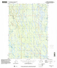
1993 Map of Tyonek D-2
USGS Topo · Published 2001About this map
The Kahiltna River and Yentna River dominate the drainage patterns of this Alaskan landscape, captured during a period of transition in mapping technology between 1952 and 1993. The terrain is a complex network of wetlands and wandering water bodies, including Kroto Cr and Deshka River, indicating a low-lying riparian environment where seasonal travel was essential. The scarcity of permanent structures is evidenced by an isolated Cabin and a sparse network of pathways designated as Winter Trail or 4wd routes. These labels reflect a wilderness area where navigation was largely dictated by frozen ground or specialized vehicles. Significant lakes like Neil Lake, Lockwood Lake, and Brevig Lake dot the map, providing fixed landmarks for bush pilots and hunters navigating the numerous unnamed channels and marshy stretches between the major river forks.
Find a feature on this map
18 named features on this map. Tap any name to fly to it.
Don’t see what you’re looking for? This feature index may not catch every label — zoom into the map to look around manually.
Map Details
Editions of this 1993 Tyonek D-2 Map
This is the sole edition of this map. No revisions or reprints were ever made.
Other maps of this area

1949 · Tyonek
USGS Topo · 1:250,000

1950 · Talkeetna
USGS Topo · 1:250,000

1951 · Talkeetna
USGS Topo · 1:250,000

1951 · Tyonek
USGS Topo · 1:250,000

1952 · Tyonek D-1
USGS Topo · 1:63,360

1952 · Talkeetna A-1
USGS Topo · 1:63,360

1952 · Tyonek C-1
USGS Topo · 1:63,360

1954 · Tyonek D-2
USGS Topo · 1:63,360

1954 · Tyonek D-3
USGS Topo · 1:63,360

1954 · Tyonek D-1
USGS Topo · 1:63,360