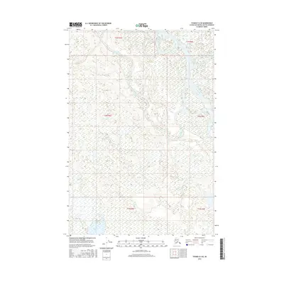
2016 Map of Tyonek D-3 SE
USGS Topo · Published 2016About this map
Alexander Lake and the winding course of the Yentna River dominate this low-lying Alaskan landscape within the Alaska-Matanuska-Susitna Borough. The area is defined by a dense network of braided channels and wetlands, illustrating the complex hydrology typical of the region. The Twentymile Slough and Indian Cr carve through the terrain, showing the dynamic shifts of water across the flats. This 2016 survey provides a clear view of the wilderness before significant human infrastructure, focusing instead on the natural drainage patterns of Deep Cr and the surrounding basin. For those studying the environmental history of the Susitna Valley, the map offers a precise record of water levels and river positions at the time of the imagery.
Find a feature on this map
6 named features on this map. Tap any name to fly to it.
Don’t see what you’re looking for? This feature index may not catch every label — zoom into the map to look around manually.
Map Details
Editions of this 2016 Tyonek D-3 SE Map
This is the sole edition of this map. No revisions or reprints were ever made.
Other maps of this area

1949 · Tyonek
USGS Topo · 1:250,000

1951 · Tyonek
USGS Topo · 1:250,000

1954 · Tyonek D-2
USGS Topo · 1:63,360

1954 · Tyonek D-3
USGS Topo · 1:63,360

1954 · Tyonek C-3
USGS Topo · 1:63,360

1958 · Tyonek C-2
USGS Topo · 1:63,360

1958 · Tyonek
USGS Topo · 1:250,000

1965 · Tyonek
USGS Topo · 1:250,000
1993 · Tyonek D-3
USGS Topo · 1:63,360
1993 · Tyonek D-2
USGS Topo · 1:63,360