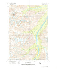
1958 Map of Tyonek D-8
USGS Topo · Published 1963About this map
Mount Estelle and Cathedral Mountain anchor this 1958 survey of the Alaskan interior, a landscape defined by massive ice flows and glacial drainage systems. The Skwentna River serves as the primary corridor through the terrain, fed by a network of tributaries including Muddy Creek and Black and Tan Creek. The topography is dominated by the Black and Tan Glacier in the southeast and the Stoney Glacier in the north, providing a clear record of the area's glaciology before later twentieth-century shifts. This map, based on 1957 aerial photography, captures the region in a pristine state with no roads or trails yet established. Features like Portage Pass and Mount Stoney represent the landmark-based navigation necessary for travel in this unsurveyed territory, where land lines were predetermined by the Bureau of Land Management rather than established by ground survey.
Find a feature on this map
12 named features on this map. Tap any name to fly to it.
Don’t see what you’re looking for? This feature index may not catch every label — zoom into the map to look around manually.
Map Details
Editions of this 1958 Tyonek D-8 Map
2 editions found

Other maps of this area

1949 · Tyonek
USGS Topo · 1:250,000

1949 · McGrath
USGS Topo · 1:250,000

1950 · McGrath
USGS Topo · 1:250,000

1950 · Talkeetna
USGS Topo · 1:250,000

1951 · Talkeetna
USGS Topo · 1:250,000

1951 · Tyonek
USGS Topo · 1:250,000

1951 · Lime Hills
USGS Topo · 1:250,000

1958 · Talkeetna A-6
USGS Topo · 1:63,360

1958 · Tyonek C-8
USGS Topo · 1:63,360

1958 · McGrath A-1
USGS Topo · 1:63,360