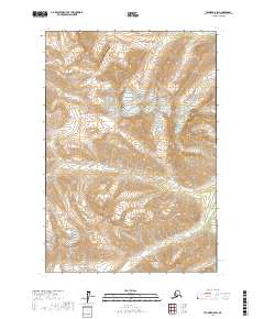
2017 Map of Tyonek D-8 SW
USGS Topo · Published 2017About this map
Mt Estelle serves as a prominent landmark within the Alaska Range on this high-latitude topographic study in Matanuska-Susitna. The landscape is defined by its complex drainage systems, where glacial and snowmelt runoff feed into several named watercourses. Timber Cr flows through the western reaches, while the northern and southern sectors are marked by Muddy Cr and Emerald Cr, respectively. The mapping highlights the intersection of several survey townships, including t20n r20w and t21n r20w, providing a clear view of the public land survey system divisions across this high-elevation terrain. This 2017 edition records the natural state of the area's hydrology and topography, capturing the raw alignment of peaks and creek beds as they existed at the time of the SPOT imagery survey.
Find a feature on this map
11 named features on this map. Tap any name to fly to it.
Don’t see what you’re looking for? This feature index may not catch every label — zoom into the map to look around manually.
Map Details
Editions of this 2017 Tyonek D-8 SW Map
This is the sole edition of this map. No revisions or reprints were ever made.
Other maps of this area

1949 · Tyonek
USGS Topo · 1:250,000

1951 · Tyonek
USGS Topo · 1:250,000

1951 · Lime Hills
USGS Topo · 1:250,000

1958 · Tyonek C-8
USGS Topo · 1:63,360

1958 · Tyonek D-8
USGS Topo · 1:63,360

1958 · Tyonek
USGS Topo · 1:250,000
1958 · Lime Hills D-1
USGS Topo · 1:63,360

1958 · Lime Hills C-1
USGS Topo · 1:63,360

1958 · Lime Hills
USGS Topo · 1:250,000

1965 · Tyonek
USGS Topo · 1:250,000