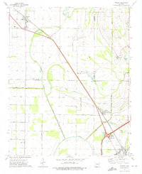
1974 Map of Tyronza
USGS Topo · Published 1976About this map
The Tyronza River winds through this section of the Arkansas delta, a landscape defined by an extensive drainage network including Ditch No 6 and Outlet Ditch No 1. During the mid-1970s, the region was a nexus of rail and road transport, with the St Louis - San Francisco railroad corridor linking the towns of Tyronza, Gilmore, and Turrell. Smaller community centers like Beasley and Deckerville are spaced along the line, serving the surrounding agricultural plains. The map reveals the intricate water management of the Sunken Lands, where features like Dead Timber Lake and Lamb Bayou remain as remnants of the older, wetter terrain. Rural life is anchored by numerous local landmarks such as Mt Zion Ch, Cherry Bean Ch, and New Bethlehem Ch, reflecting the deep-rooted social fabric of Poinsett, Crittenden, and Mississippi counties.
Find a feature on this map
50 named features on this map. Tap any name to fly to it.
Don’t see what you’re looking for? This feature index may not catch every label — zoom into the map to look around manually.
Map Details
Editions of this 1974 Tyronza Map
This is the sole edition of this map. No revisions or reprints were ever made.
Other maps of this area

1931 · Jericho
USGS Topo · 1:62,500

1939 · Jericho
USGS Topo · 1:62,500

1939 · Evadale
USGS Topo · 1:62,500

1940 · Deckerville
USGS Topo · 1:62,500

1941 · Marked Tree
USGS Topo · 1:62,500

1952 · Jericho
USGS Topo · 1:62,500

1953 · Memphis
USGS Topo · 1:250,000

1956 · Evadale
USGS Topo · 1:62,500

1956 · Marked Tree
USGS Topo · 1:62,500

1956 · Memphis
USGS Topo · 1:250,000