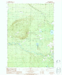
1987 Map of Udell
USGS Topo · Published 1988About this map
Udell stands near the northern edge of this landscape, situated within the expansive Manistee National Forest. The terrain is defined by the prominent Stronach Hills and Udell Hills, which rise above a complex network of wetlands and water bodies. The southern portion of the map is dominated by the winding course of the Little Manistee River, which feeds into a series of smaller lakes and swamps including Lake of the Woods and Hoppers Swamp. Evidence of historical land use and early surveying is clear through the presence of the Old Indian Treaty Boundary and several segments of an Old Railroad Grade. These features, alongside named water bodies like Stronach Creek and Timmerman Lake, illustrate the region's historical reliance on timber and waterway transport during its developmental years.
Find a feature on this map
29 named features on this map. Tap any name to fly to it.
Don’t see what you’re looking for? This feature index may not catch every label — zoom into the map to look around manually.
Map Details
Editions of this 1987 Udell Map
This is the sole edition of this map. No revisions or reprints were ever made.
Other maps of this area

1931 · Freesoil SW
USGS Topo · 1:31,680

1932 · Freesoil SE
USGS Topo · 1:31,680

1933 · Peacock SW
USGS Topo · 1:31,680

1933 · Peacock NW
USGS Topo · 1:31,680

1954 · Traverse City
USGS Topo · 1:250,000

1954 · Manitowoc
USGS Topo · 1:250,000

1956 · Onekama
USGS Topo · 1:62,500

1957 · Freesoil
USGS Topo · 1:62,500

1957 · Copemish
USGS Topo · 1:62,500

1957 · Wellston
USGS Topo · 1:62,500