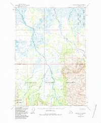
1963 Map of Ugashik A-6
USGS Topo · Published 1987About this map
The Cinder River winds through an intricate network of wetlands and volcanic drainages in this mid-century survey of the Alaska Peninsula. Braided water channels and vast marshlands dominate the northern reach, where Pumice Creek and Old Creek feed into the primary river system. The landscape transition is marked by the presence of the Aniakchak National Preserve and the Aniakchak Nat Mon in the southern portion, reflecting the region's complex conservation history. These boundaries, including the Alaska Peninsula National Wildlife Refuge, delineate protected wilderness areas defined by geological features like Lava Creek and High Creek. The map documents a territory void of roads or permanent settlements, where the drainage patterns of Ray Creek and other tributaries dictate the only navigable routes through the tundra and upland terrain.
Find a feature on this map
12 named features on this map. Tap any name to fly to it.
Don’t see what you’re looking for? This feature index may not catch every label — zoom into the map to look around manually.
Map Details
Editions of this 1963 Ugashik A-6 Map
2 editions found
Other maps of this area

1943 · Ugashik
USGS Topo · 1:250,000

1948 · Ugashik
USGS Topo · 1:250,000

1949 · Ugashik
USGS Topo · 1:250,000

1951 · Bristol Bay
USGS Topo · 1:250,000

1951 · Sutwik Island
USGS Topo · 1:250,000

1954 · Ugashik B-5
USGS Topo · 1:63,360

1963 · Ugashik B-6
USGS Topo · 1:63,360

1963 · Ugashik A-6
USGS Topo · 1:63,360

1963 · Bristol Bay
USGS Topo · 1:250,000

1963 · Bristol Bay A-1
USGS Topo · 1:63,360