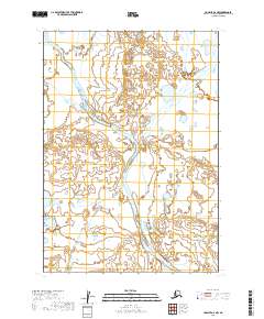
2019 Map of Ugashik A-6 NW
USGS Topo · Published 2019About this map
Cinder River dominates this landscape in the Lake and Peninsula Borough, carving a wide alluvial path through the terrain as it flows toward the coast. This modern topographic survey illustrates a complex hydrological system where the river splits into multiple braided channels, creating a shifting network of sandbars and wetlands. The surrounding area is largely defined by the Public Land Survey System grids of t34s r54w, t34s r53w, t35s r54w, and t35s r53w, reflecting the systematic mapping of this remote Alaska Peninsula region. The land here is shaped by natural forces rather than human development, with the river's meandering course and broad floodplains serving as the primary geographical markers for researchers and conservationists studying this corner of the Aleutian Range.
Find a feature on this map
5 named features on this map. Tap any name to fly to it.
Don’t see what you’re looking for? This feature index may not catch every label — zoom into the map to look around manually.
Map Details
Editions of this 2019 Ugashik A-6 NW Map
This is the sole edition of this map. No revisions or reprints were ever made.
Other maps of this area

1943 · Ugashik
USGS Topo · 1:250,000

1948 · Ugashik
USGS Topo · 1:250,000

1949 · Ugashik
USGS Topo · 1:250,000

1951 · Bristol Bay
USGS Topo · 1:250,000

1963 · Ugashik B-6
USGS Topo · 1:63,360

1963 · Ugashik A-6
USGS Topo · 1:63,360

1963 · Bristol Bay
USGS Topo · 1:250,000

1963 · Bristol Bay A-1
USGS Topo · 1:63,360
1963 · Bristol Bay B-1
USGS Topo · 1:63,360

1963 · Ugashik
USGS Topo · 1:250,000