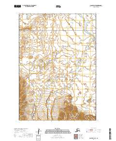
2019 Map of Ugashik A-6 SW
USGS Topo · Published 2019About this map
Aniakchak National Preserve and Aniakchak National Monument dominate this section of the Alaska Peninsula, showcasing a landscape defined by volcanic geology and remote waterways. In the northern reaches of the quadrangle, Cinder River flows northwest toward Bristol Bay, while Lava Cr and High Cr drain the central and southern terrain. This 2019 survey documents the intricate drainage patterns and elevation contours surrounding one of the most wild volcanic features in the world. The boundary between the national preserve and monument bisects the southwestern corner, marking a transition in land management and preservation within this roadless wilderness area of the Lake and Peninsula Borough.
Find a feature on this map
11 named features on this map. Tap any name to fly to it.
Don’t see what you’re looking for? This feature index may not catch every label — zoom into the map to look around manually.
Map Details
Editions of this 2019 Ugashik A-6 SW Map
This is the sole edition of this map. No revisions or reprints were ever made.
Other maps of this area

1943 · Ugashik
USGS Topo · 1:250,000

1948 · Ugashik
USGS Topo · 1:250,000

1949 · Ugashik
USGS Topo · 1:250,000

1951 · Bristol Bay
USGS Topo · 1:250,000

1951 · Sutwik Island
USGS Topo · 1:250,000

1963 · Ugashik A-6
USGS Topo · 1:63,360

1963 · Bristol Bay
USGS Topo · 1:250,000

1963 · Bristol Bay A-1
USGS Topo · 1:63,360

1963 · Sutwik Island
USGS Topo · 1:250,000

1963 · Chignik
USGS Topo · 1:250,000