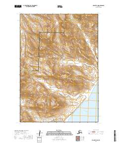
2019 Map of Ugashik B-2 NE
USGS Topo · Published 2019About this map
The coastal interface of Wide Bay meets the dramatic elevations of the Alaska Peninsula in this modern topographical study. The landscape is defined by the sharp rise toward Mt Shannon and the natural transit point at Sids Pass. This area, marking the boundary between Lake and Peninsula Borough and Kodiak Island Borough, is deeply etched by a network of drainage systems including Des Moines Cr, Pass Cr, and Black Cr. The map illustrates the complex drainage patterns where Deer Cr and Short Cr descend toward the sea, highlighting a region where the geography is shaped by the constant interaction between mountainous terrain and the Pacific coastline.
Find a feature on this map
12 named features on this map. Tap any name to fly to it.
Don’t see what you’re looking for? This feature index may not catch every label — zoom into the map to look around manually.
Map Details
Editions of this 2019 Ugashik B-2 NE Map
This is the sole edition of this map. No revisions or reprints were ever made.
Other maps of this area

1943 · Ugashik
USGS Topo · 1:250,000

1948 · Ugashik
USGS Topo · 1:250,000

1949 · Ugashik
USGS Topo · 1:250,000

1951 · Ugashik B-1
USGS Topo · 1:63,360

1951 · Ugashik C-1
USGS Topo · 1:63,360

1951 · Ugashik C-2
USGS Topo · 1:63,360

1951 · Ugashik B-2
USGS Topo · 1:63,360

1963 · Ugashik
USGS Topo · 1:250,000
2019 · Ugashik C-2 SE
USGS Topo · 1:25,000
2019 · Ugashik B-2 SW
USGS Topo · 1:25,000