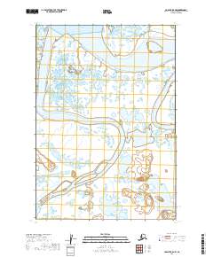
2019 Map of Ugashik B-5 NW
USGS Topo · Published 2019About this map
Ugashik Bay and the eastern edge of Bristol Bay dominate this coastal landscape in the Lake and Peninsula Borough. The map reveals an intricate aqueous network where the Ugashik River meets the tide, characterized by a complex pattern of estuarine channels and low-lying wetlands. Further inland, the terrain is defined by the convergence of major salmon-bearing waterways, including the King Salmon River and the Dog Salmon River. The lack of named settlements or roads reflects the remote, wilderness character of this region, emphasizing its status as an unpopulated ecological corridor where the land is primarily shaped by the shifting hydrology of these river systems.
Find a feature on this map
9 named features on this map. Tap any name to fly to it.
Don’t see what you’re looking for? This feature index may not catch every label — zoom into the map to look around manually.
Map Details
Editions of this 2019 Ugashik B-5 NW Map
This is the sole edition of this map. No revisions or reprints were ever made.
Other maps of this area

1943 · Ugashik
USGS Topo · 1:250,000

1948 · Ugashik
USGS Topo · 1:250,000

1949 · Ugashik
USGS Topo · 1:250,000

1951 · Ugashik C-5
USGS Topo · 1:63,360

1951 · Ugashik C-6
USGS Topo · 1:63,360

1954 · Ugashik B-5
USGS Topo · 1:63,360

1963 · Ugashik B-6
USGS Topo · 1:63,360

1963 · Ugashik
USGS Topo · 1:250,000
2019 · Ugashik B-5 SW
USGS Topo · 1:25,000
2019 · Ugashik C-5 SE
USGS Topo · 1:25,000