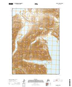
2019 Map of Ugashik C-1 SE
USGS Topo · Published 2019About this map
Kanatak Trail serves as a critical overland link in this coastal region of the Alaska Peninsula, cutting through the high point at Kanatak Pass to connect the inland waters of Becharof Lake with the maritime reach of Portage Bay. This 2019 survey documents a landscape of dramatic elevation changes, dominated by the massif of Mt Becharof.
Find a feature on this map
19 named features on this map. Tap any name to fly to it.
Don’t see what you’re looking for? This feature index may not catch every label — zoom into the map to look around manually.
Map Details
Editions of this 2019 Ugashik C-1 SE Map
This is the sole edition of this map. No revisions or reprints were ever made.
Other maps of this area

1943 · Ugashik
USGS Topo · 1:250,000

1948 · Ugashik
USGS Topo · 1:250,000

1949 · Ugashik
USGS Topo · 1:250,000

1951 · Karluk
USGS Topo · 1:250,000

1951 · Ugashik B-1
USGS Topo · 1:63,360

1951 · Ugashik C-1
USGS Topo · 1:63,360
1951 · Karluk C-6
USGS Topo · 1:63,360

1952 · Karluk
USGS Topo · 1:250,000

1963 · Ugashik
USGS Topo · 1:250,000

1964 · Karluk
USGS Topo · 1:250,000