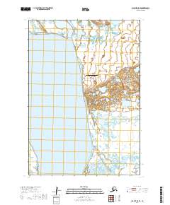
2019 Map of Ugashik C-5 SW
USGS Topo · Published 2019About this map
Pilot Point stands as the primary settlement on this portion of the Alaska Peninsula, situated along the eastern reaches of Bristol Bay where it meets Ugashik Bay. The landscape is defined by the transition from the tidal waters of the Bering Sea to a complex network of coastal wetlands and low-lying terrain. Local infrastructure is concentrated around the village, including the Pilot Point Airport and a small network of roads such as Dago Creek Road and Shangin Road that connect the community to its immediate environment. This 2019 data reflects the modern footprint of a community historically tied to the commercial fishing industry and subsistence living in the Lake and Peninsula Borough. The map detail highlights the specific interaction between the shoreline and the upland areas, illustrating the geographic isolation and specialized transport needs of this remote coastal region.
Find a feature on this map
12 named features on this map. Tap any name to fly to it.
Don’t see what you’re looking for? This feature index may not catch every label — zoom into the map to look around manually.
Map Details
Editions of this 2019 Ugashik C-5 SW Map
This is the sole edition of this map. No revisions or reprints were ever made.
Other maps of this area

1943 · Ugashik
USGS Topo · 1:250,000

1948 · Ugashik
USGS Topo · 1:250,000

1949 · Ugashik
USGS Topo · 1:250,000

1951 · Ugashik C-5
USGS Topo · 1:63,360

1951 · Ugashik C-6
USGS Topo · 1:63,360

1954 · Ugashik B-5
USGS Topo · 1:63,360

1963 · Ugashik B-6
USGS Topo · 1:63,360

1963 · Ugashik
USGS Topo · 1:250,000
2019 · Ugashik C-5 SE
USGS Topo · 1:25,000
2019 · Ugashik C-5 NW
USGS Topo · 1:25,000