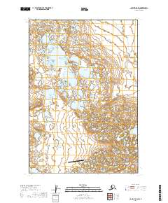
2019 Map of Ugashik D-4 NE
USGS Topo · Published 2019About this map
Fort Jensen Airport sits as the primary man-made landmark in this sparsely settled region of the Alaska Peninsula. The landscape is defined by an intricate network of wetlands and small water bodies that stretch across the survey area. Mapping from the U.S. Geological Survey details the legal boundaries of the Lake and Peninsula borough, showing the township and range divisions such as t26s r48w and t25s r47w. This terrain reflects the remote nature of the region, where infrastructure is limited to essential transportation hubs like the local airstrip. The detailed hydrography and contour lines provide an essential view of the drainage patterns and low-lying geography characteristic of the coastal tundra environment near the turn of the twenty-first century.
Find a feature on this map
7 named features on this map. Tap any name to fly to it.
Don’t see what you’re looking for? This feature index may not catch every label — zoom into the map to look around manually.
Map Details
Editions of this 2019 Ugashik D-4 NE Map
This is the sole edition of this map. No revisions or reprints were ever made.
Other maps of this area

1943 · Ugashik
USGS Topo · 1:250,000

1948 · Ugashik
USGS Topo · 1:250,000

1949 · Ugashik
USGS Topo · 1:250,000

1951 · Ugashik D-3
USGS Topo · 1:63,360

1951 · Ugashik D-4
USGS Topo · 1:63,360

1951 · Naknek A-4
USGS Topo · 1:63,360

1951 · Naknek A-3
USGS Topo · 1:63,360

1952 · Naknek
USGS Topo · 1:250,000

1963 · Ugashik
USGS Topo · 1:250,000

1964 · Naknek
USGS Topo · 1:250,000