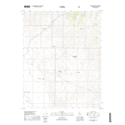
2018 Map of Uhlmeyer Spring
USGS Topo · Published 2018About this map
Monola sits at the southwestern edge of this landscape, positioned where the floor of the Owens Valley meets the rising slopes of the White- Inyo Range. This territory is defined by its critical water sources, with Uhlmeyer Spring, Wilkerson Springs, and Batchelder Spring providing essential points of relief in a high-elevation desert environment. The presence of these named springs suggests their importance for historical travel and livestock management within the Inyo National Forest.
Find a feature on this map
21 named features on this map. Tap any name to fly to it.
Don’t see what you’re looking for? This feature index may not catch every label — zoom into the map to look around manually.
Map Details
Editions of this 2018 Uhlmeyer Spring Map
This is the sole edition of this map. No revisions or reprints were ever made.
Other maps of this area

1913 · Bishop
USGS Topo · 1:125,000

1947 · Mariposa
USGS Topo · 1:250,000

1948 · Mariposa
USGS Topo · 1:250,000

1949 · Bishop
USGS Topo · 1:62,500

1950 · Big Pine
USGS Topo · 1:62,500

1951 · Bishop
USGS Topo · 1:62,500

1951 · Blanco Mountain
USGS Topo · 1:62,500

1951 · Waucoba Mtn.
USGS Topo · 1:62,500

1957 · Mariposa
USGS Topo · 1:250,000
1958 · Waucoba Mtn
USGS Topo · 1:62,500