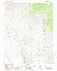
1987 Map of Uhlmeyer Spring
USGS Topo · Published 1987About this map
The Owens River flows through the floor of the Owens Valley in this late-twentieth-century study of the high desert interface between the White Mountains and the Inyo Mountains. The landscape is defined by its water sources and mining history, with vital watering holes such as Wilkerson Springs, Uhlmeyer Spring, and Batchelder Spring punctuating the arid terrain. Human activity is evidenced by scattered Prospects, a Mine, and Gravel Pits located near the National Forest Boundary. A complex network of 4wd tracks provides the primary access through steep drainages like Soldier Canyon and Crooked Road Canyon. This provisional survey preserves the topographical details of the Inyo National Forest as it existed in the 1980s, emphasizing the reliance on natural springs and rugged trail systems for navigation and resource extraction.
Find a feature on this map
19 named features on this map. Tap any name to fly to it.
Don’t see what you’re looking for? This feature index may not catch every label — zoom into the map to look around manually.
Map Details
Editions of this 1987 Uhlmeyer Spring Map
This is the sole edition of this map. No revisions or reprints were ever made.
Other maps of this area

1913 · Bishop
USGS Topo · 1:125,000

1947 · Mariposa
USGS Topo · 1:250,000

1948 · Mariposa
USGS Topo · 1:250,000

1949 · Bishop
USGS Topo · 1:62,500

1950 · Big Pine
USGS Topo · 1:62,500

1951 · Bishop
USGS Topo · 1:62,500

1951 · Blanco Mountain
USGS Topo · 1:62,500

1951 · Waucoba Mtn.
USGS Topo · 1:62,500

1957 · Mariposa
USGS Topo · 1:250,000
1958 · Waucoba Mtn
USGS Topo · 1:62,500