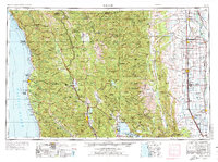
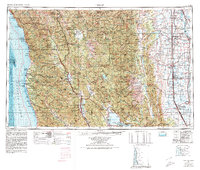
1957 Map of Ukiah
USGS Topo · Published 1974About this map
Round Valley Indian Reservation and the rugged Coast Ranges anchor this mid-century view of Northern California, where the timber and agricultural economies met the Pacific. The Northwestern Pacific RR follows the Russian River and Eel River corridors, providing a critical link for inland settlements like Ukiah and Willits to the coast. Along the shore, the legacy of the redwood trade is visible through towns such as Fort Bragg and Mendocino, while the Jackson State Forest covers the interior ridges. Eastward, the terrain drops into the Sacramento Valley, marked by the industrial engineering of the Tehama-Colusa Canal and large-scale waterfowl conservation at the Sacramento National Wildlife Refuge. This survey captures the region before modern development, showing the intricate network of state highways like State Highway 1 and State Highway 128 connecting isolated ranching valleys and coastal ports.
Find a feature on this map
214 named features on this map. Tap any name to fly to it.
Don’t see what you’re looking for? This feature index may not catch every label — zoom into the map to look around manually.
Map Details
Editions of this 1957 Ukiah Map
3 editions found

Other maps of this area

1886 · Lassen Peak
USGS Topo · 1:250,000

1888 · Marysville
USGS Topo · 1:125,000

1890 · Red Bluff
USGS Topo · 1:250,000

1891 · Chico
USGS Topo · 1:125,000

1891 · Marysville
USGS Topo · 1:125,000

1892 · Lassen Peak
USGS Topo · 1:250,000

1893 · Chico
USGS Topo · 1:125,000

1894 · Lassen Peak
USGS Topo · 1:250,000

1894 · Marysville
USGS Topo · 1:125,000

1894 · Red Bluff
USGS Topo · 1:250,000